Kanchenjunga · 13 Days
Kanchenjunga South Base Camp Trek - 13 Days
Duration
13 Days
Max Altitude
4,730m (15,518 ft)
at Oktang viewpoint
Grade
Strenuous
Lodging
Teahouse / Lodge
Overview
The Kanchenjunga south base camp trek is the shorter, less-walked sister of the north route. Over 13 days it climbs from the tea gardens of Ilam to the Yalung Glacier - the southern toe of Kanchenjunga (8,586m) - via the Limbu, Rai and Sherpa villages of the lower Tamur and Simbuwa valleys. The high point at Oktang (4,730m) gives a head-on view of the south face of Kanchenjunga and its three companion summits, often called the "Three Sisters."
This is one of the quietest 8,000m-mountain-foot treks in Nepal. The trail receives only a few hundred trekkers per year and lodges are simple but spaced reasonably close. The route balances real altitude with a shorter trip length than the north or full-circuit alternatives, making it the choice for trekkers wanting a true Kanchenjunga experience without a three-week commitment.
Highlights
- Sunrise on Kanchenjunga's south face from Oktang (4,730m)
- Walk the Yalung Glacier moraine - the southern foot of the world's third highest mountain
- Pass through Limbu, Rai and Sherpa villages of the lower Tamur valley
- Cross Lasiya Bhanjyang (3,310m) ridge with a panoramic mountain horizon
- Possible red panda sightings in the Torangden forest belt
- Yak meadows and blue sheep above Ramche
- Exit through Ilam's tea gardens for a varied finish
- Restricted-area permits and conservation entry handled in advance
- Acclimatisation profile designed for progressive sleeping altitudes
- Senior licensed guide and shared porter included
Itinerary
Day 1
Arrive in Kathmandu (1,400m)
🍽 Welcome dinner
Day 1
Arrive in Kathmandu (1,400m)
🍽 Welcome dinner
Day 2
Fly Kathmandu to Bhadrapur, drive to Taplejung (1,820m)
↔ 45-min flight + 7-8 hour drive
🍽 Breakfast, Lunch, Dinner
Day 2
Fly Kathmandu to Bhadrapur, drive to Taplejung (1,820m)
↔ 45-min flight + 7-8 hour drive 🍽 Breakfast, Lunch, Dinner
Day 3
Jeep to Taplethok, trek to Hellok (1,420m)
⏱ 3-4 hour drive + short trek
🍽 Breakfast, Lunch, Dinner
Day 3
Jeep to Taplethok, trek to Hellok (1,420m)
⏱ 3-4 hour drive + short trek 🍽 Breakfast, Lunch, Dinner
Day 4
Hellok to Yasang (2,150m)
⏱ 4 hours
🍽 Breakfast, Lunch, Dinner
Day 4
Hellok to Yasang (2,150m)
⏱ 4 hours 🍽 Breakfast, Lunch, Dinner
Day 5
Yasang to Torangden (2,995m)
⏱ 5 hours
🍽 Breakfast, Lunch, Dinner
Day 5
Yasang to Torangden (2,995m)
⏱ 5 hours 🍽 Breakfast, Lunch, Dinner
Day 6
Torangden to Cheram (3,870m)
⏱ 5-6 hours
🍽 Breakfast, Lunch, Dinner
Day 6
Torangden to Cheram (3,870m)
⏱ 5-6 hours 🍽 Breakfast, Lunch, Dinner
Day 7
Cheram to Ramche (4,580m)
⏱ 4-5 hours
🍽 Breakfast, Lunch, Dinner
Day 7
Cheram to Ramche (4,580m)
⏱ 4-5 hours 🍽 Breakfast, Lunch, Dinner
Day 8
Ramche to Oktang (4,730m), return and descend to Cheram (3,870m)
⏱ 6-7 hours total
▲ 4,730m
🍽 Breakfast, Lunch, Dinner
Day 8
Ramche to Oktang (4,730m), return and descend to Cheram (3,870m)
⏱ 6-7 hours total ▲ 4,730m 🍽 Breakfast, Lunch, Dinner
Day 9
Cheram to Torangden (2,995m) via Lasiya Bhanjyang
⏱ 6 hours
🍽 Breakfast, Lunch, Dinner
Day 9
Cheram to Torangden (2,995m) via Lasiya Bhanjyang
⏱ 6 hours 🍽 Breakfast, Lunch, Dinner
Day 10
Torangden to Yamphudin (2,080m)
⏱ 5-6 hours
🍽 Breakfast, Lunch, Dinner
Day 10
Torangden to Yamphudin (2,080m)
⏱ 5-6 hours 🍽 Breakfast, Lunch, Dinner
Day 11
Drive Yamphudin to Ilam (800m)
⏱ 5-6 hours
🍽 Breakfast, Lunch, Dinner
Day 11
Drive Yamphudin to Ilam (800m)
⏱ 5-6 hours 🍽 Breakfast, Lunch, Dinner
Day 12
Drive to Bhadrapur, fly to Kathmandu
⏱ 3-hour drive + 40-min flight
🍽 Breakfast
Day 12
Drive to Bhadrapur, fly to Kathmandu
⏱ 3-hour drive + 40-min flight 🍽 Breakfast
Day 13
Final departure
🍽 Breakfast
Day 13
Final departure
🍽 Breakfast
Ready to walk this?
Enquire now →What's included
Included
- Kathmandu-Bhadrapur return flights
- Private jeep transfers from Bhadrapur to Taplethok and back via Ilam
- 2 nights' Kathmandu accommodation (3-star, BB plan)
- Twin-share teahouse accommodation on the trek
- All meals (breakfast, lunch, dinner) during the trek
- Government-licensed English-speaking guide
- 1 porter for every 2 trekkers (20 kg load limit)
- Kanchenjunga Conservation Area Project (KCAP) permit
- Kanchenjunga Restricted Area Permit
- Group first-aid kit and oximeter
- HHT company duffel bag
- All applicable government taxes
Not included
- Nepal entry visa
- International airfare
- Travel insurance covering trekking to 5,000m with helicopter rescue (mandatory)
- Lunches and dinners in Kathmandu
- Hot showers, Wi-Fi and device charging in teahouses
- Bottled water and alcoholic drinks
- Personal trekking equipment
- Tips for crew and drivers
- Costs from weather or flight delays
Trek guide
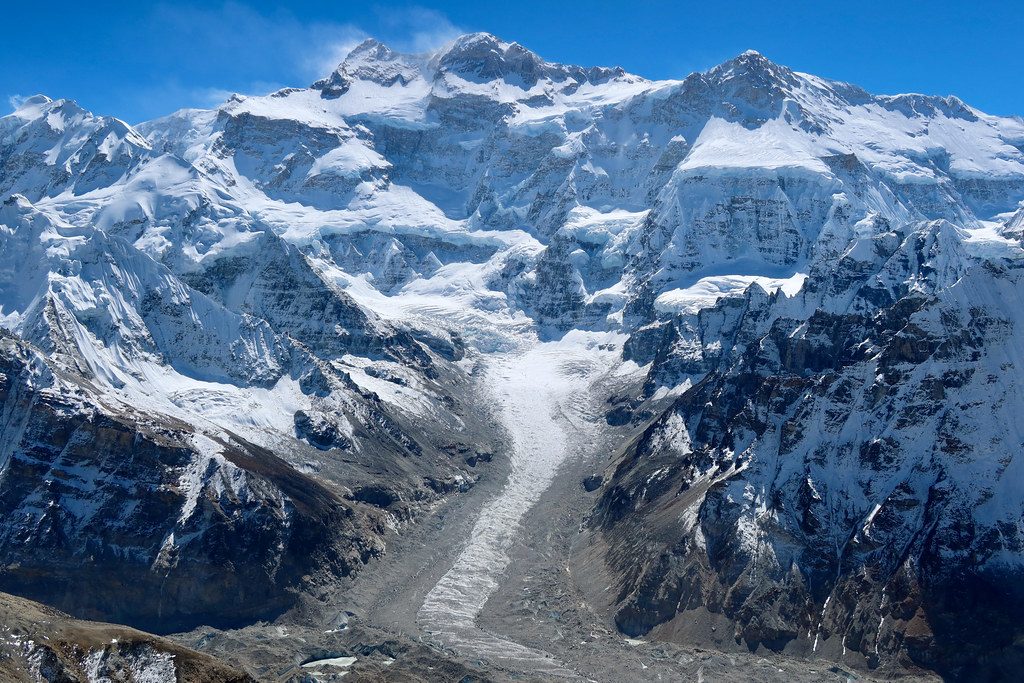
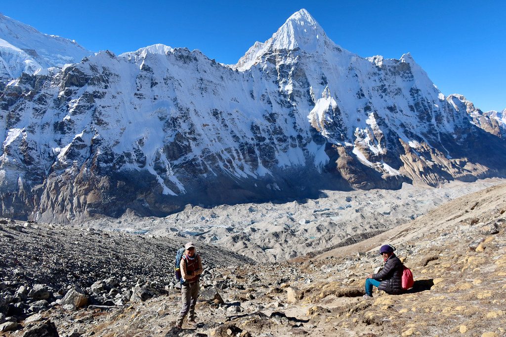
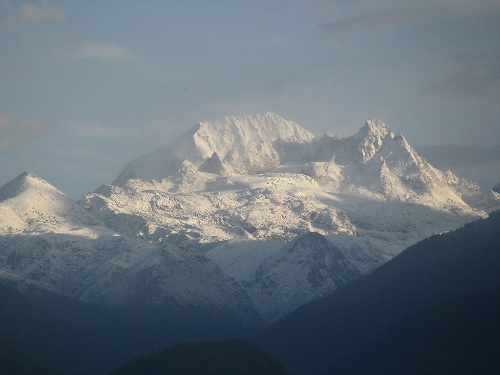
The South Face
Kanchenjunga's south face is the lesser-photographed side of the mountain but arguably its most architectural - a 3-km vertical wall of rock and hanging glacier rising from the Yalung valley. The British 1955 first ascent team approached from this side. Today only the Yalung-Oktang viewpoint is open to non-mountaineering trekkers; the base camp itself sits at the foot of the Yalung Glacier.
Yalung Glacier and Oktang
Oktang is a small Buddhist shrine at 4,730m on a moraine ridge above the Yalung Glacier. It is the highest accessible viewpoint on the south route and the classic sunrise vantage for the south face. The walk from Ramche takes roughly 45 minutes pre-dawn.
Restricted Area
Like the north route, the south Kanchenjunga trail requires a restricted-area permit, mandatory licensed guide and minimum group of 2. We process permits in Kathmandu before departure.
Climate Zones
- Days 1-3: Sub-tropical. Cardamom, banana, terraced rice.
- Days 4-5: Temperate. Oak, rhododendron, red panda habitat.
- Days 6-7: Sub-alpine. Birch, juniper, dwarf rhododendron, yak pasture.
- Day 8: Glacial. Yalung moraine.
Acclimatisation
Sleeping altitudes progress steadily - Cheram 3,870m, Ramche 4,580m, then the climb-high day to Oktang 4,730m followed by descent to Cheram. This sleep-low-after-high profile suits trekkers without prior 4,000m+ experience.
Best Season
- Spring (April-May): Rhododendrons in flower, longer days, warmer nights
- Autumn (October-November): Driest skies, clearest mountain views, colder above 4,000m
We do not run this trek in monsoon (June-September) due to leech-heavy forest and landslide-prone roads. Winter is possible but lodges may close.
Fitness
Strenuous. 4-6 hour days, basic lodges and altitude above 4,700m. 3-4 months of cardio and leg-strength training. Prior multi-day trekking experience strongly recommended; high-altitude experience helpful but not essential.
Packing list
Clothing: Down jacket -10C, fleece mid-layer, waterproof shell, soft-shell trousers, 3 trekking shirts, 2 trousers, base layers, 5 pairs hiking socks, beanie, sun hat, buff, insulated and liner gloves
Footwear: Waterproof high-ankle trekking boots, gaiters, camp shoes
Accessories: 40L daypack, 65L porter duffel, -10C sleeping bag, trekking poles, headlamp + spare batteries, polarised sunglasses, 2L water capacity, water purification, power bank, adapter
Documents: Passport with Nepal visa, insurance certificate, 4 passport photos
Medical: Diamox 250mg, painkillers, antihistamines, blister care, SPF 50+ sunscreen, lip balm, rehydration salts
Frequently asked questions
How does this compare to the north base camp?
Can I do both north and south?
How fit do I need to be?
Is a guide mandatory?
What permits are needed?
How are the lodges?
How cold does it get?
Will I see red pandas?
Is the Bhadrapur flight reliable?
Can the itinerary be shortened?
Still have questions? Talk to a guide →
Why book this with us
Senior local guides. Small groups. Honest pricing.
- Departures led by a guide who grew up in the region.
- Max 8 trekkers per group — no convoys.
- 100% Nepali-owned. Profit stays in the valleys.
- Free cancellation up to 30 days before departure.
- Permits, internal flights and TIMS handled by us.
- 24/7 in-country support during your trek.